

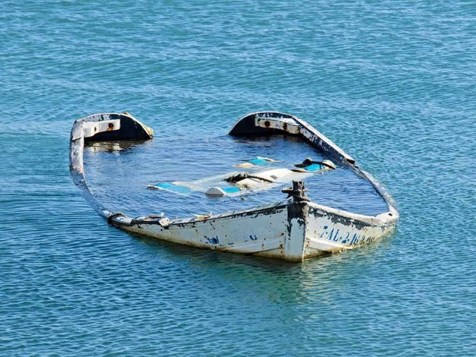
When a great river recedes, it does more than strand barges; it peels back layers of industrial and wartime history that modern Europe built over and then forgot.
At a Glance
- Exceptionally low Danube water levels in Croatia and Serbia exposed long-submerged wrecks, including a freight ship reported to have sunk in 1937.
- This exposure fits a repeatable pattern: drought-driven drawdowns routinely bring hidden riverbed artifacts to light along the Danube corridor.
- Multiple outlets corroborate the hydrologic trigger and the reappearance of decades-old wrecks; the phenomenon has parallels documented in 2022 and subsequent low-water years.
- The precise naming of a specific Croatian wreck remains under local investigation; early labels travel faster than archival confirmations.
What low water reveals, and why it keeps happening
Rivers are archives as much as they are arteries. The Danube’s bed shelves hold hulls, barge frames, bridge fragments, anchors, munitions, and the everyday detritus of trade. Most years, these deposits remain buried beneath meters of water and silt. During prolonged dry spells, however, the river’s stage falls below familiar thresholds, and features the channel has hidden for decades surface into view. Recent reporting from Croatia and Serbia placed the Danube at unusually low levels, with a freight vessel reported as lost in 1937 newly exposed in Croatia; in eastern Serbia, the outlines of scuttled German warships again protruded from the channel near Prahovo. The cause-and-effect chain is direct: drought constricts inflows, navigation authorities record historic or near-historic gauge readings, and submerged structures emerge.
Two dynamics make the Danube particularly prone to these spectacles. First, it is long—nearly 1,800 miles—and hydrologically complex, draining Alpine, Carpathian, and Balkan catchments that respond unevenly to heat and precipitation anomalies. Second, its 20th-century history layered commerce and conflict atop one another. The industrial barge traffic that connected Central Europe to the Black Sea left behind peacetime wrecks; World War II added scuttled flotillas and explosive cargoes. When water drops, you do not need divers and sonar to confirm the archive; it rises in rust and rivets on its own.
The 1937 freight ship and the Croatian site
Recent video and text coverage converged on a compelling detail: a freight ship, lost in 1937, now visible along the Croatian reach of the river. The story resonates because it predates the Danube’s wartime wreckyard and hints at commercial mishap rather than combat. Local officials, confronted with a skeletal hull near Opatovac, initiated a historical inquiry to nail down provenance and identity—exactly what conscientious heritage stewards should do when media attention arrives before the records do. That process typically draws on municipal archives, accident notices, insurance registries, and surviving crew or company documentation; where the paper trail thins, investigators measure the hull, photograph distinctive framing patterns, and compare machinery footprints against known specifications to match artifact to name. Until those steps are complete, a site may properly remain a “mystery shipwreck” even as reporting references a likely 1937 loss.
This sequencing—first the striking images, then the careful identification—is not a failure of journalism or heritage work. It is the tempo of river archaeology during drought. The camera can show you what is there; the ledger and the caliper tell you exactly which ship it was and why it lies where it does. In this case, multiple outlets agree on the central facts: the Danube fell sharply, and decades-old wreckage is now visible in Croatia and Serbia; some reports specifically mention a 1937 freight ship exposure on the Croatian side. Those are strong, mutually reinforcing claims. The narrower label some viewers or readers may have seen—the Hungarian cargo ship Fulton—belongs, for now, in the investigator’s file rather than in definitive copy unless and until primary documentation closes the loop.
Mechanism: from drought signal to wreck exposure
Hydrologically, the path from heatwave to hull is well understood. Prolonged high temperatures accelerate evapotranspiration, while persistent precipitation deficits suppress basin recharge; the Danube’s tributaries then deliver less volume to the main stem, and the river’s stage drops. Navigation agencies track these shifts at fixed gauges—Budapest, Mohács, Prahovo, Galați among others—where “lowest since” and “near-record low” readings provide context beyond local observation. In such years, bottlenecks in the channel appear: gravel bars extend, bridge piers stand proud, and long-known but normally covered hulks reemerge. That is what 2022 showed with stark clarity near Prahovo, where low water revealed dozens of German warships scuttled in 1944, some still loaded with munitions; contemporary drought years have echoed that pattern, though not always to the same geographic extent.
Exposure is seldom uniform. A wreck protruding near Prahovo might be fully buried by silt in a normal year and lethal to a passing hull in a low one. Conversely, artifacts in deeper thalwegs remain invisible even during drought. This spatial variability explains why, in the same reporting arc, you see Croatian sites exposing prewar commercial wreckage while Serbian reaches reveal wartime hulks. The shared driver is the river’s low stage; the particulars are local hydraulics and channel morphology.
Record-low versus repeatable low: framing the claim
“Record-low” is a phrase that catches attention and invites skepticism in equal measure. The Danube has well-instrumented gauges along its length; some segments indeed register lows unprecedented in the modern record, while others fall to “lowest in decades” or “near-record” categories. Recent reporting distinguished these nuances, noting Romanian gauges at their lowest since the mid-1990s and Hungarian segments hitting near-record thresholds that disrupted tourism traffic; in parallel, Croatian and Serbian reaches dropped enough to expose wreckage. The distinction matters for historical comparison but not for the basic fact at hand: in all these cases, water fell sufficiently to reveal decades-old vessels. When historians or hydrologists later parse whether a given site tied or broke a record, the presence of exposed hulls remains indisputable.
This is why seasoned observers treat “unprecedented exposure” claims cautiously. The Danube has revealed its hidden archive before, notably in 2022’s severe drought; it will do so again. The remarkable part is not that wrecks appeared, but which ones, where, and with what safety and heritage implications.
Safety, heritage, and river management implications
Exposure is not just a curiosity. Wartime wrecks near Prahovo still contain explosives; low water brings their hazards into shallow, navigable lanes, complicating barge traffic and raising the stakes for salvage. Even inert wrecks can reshape flow and scour, forcing pilots to thread narrower channels or idling cruise ships altogether until levels rise. Tourism operators feel the pinch early; agriculture, dependent on irrigation intakes and barge-borne inputs, is not far behind. The recent drawdowns north of Budapest and along Romanian reaches stranded vessels and curtailed sightseeing traffic—a reminder that the Danube is economic infrastructure first and a theater of historical rediscovery second.
For heritage managers, droughts compress multi-year research into a few navigable weeks. Once a wreck surfaces, officials must document it quickly—photogrammetry, measured drawings, artifact cataloging—before weather, scavenging, or renewed flow erases evidence. Localities that prepare protocols in advance—clear reporting lines, collaboration agreements with museums and universities, and public-risk signage—are better positioned to balance curiosity with conservation. Croatia’s decision to open a formal inquiry into the exposed wreck’s origin is a textbook move: establish identity carefully, coordinate with navigation authorities, and decide whether to mark, stabilize, or study in situ.
How identification is made—and why patience matters
Pinning a proper name on a skeletal hull is exacting work. Investigators start with archival leads: newspaper accounts of accidents, insurance claims, port registries, towing logs, and river authority incident cards. They crosswalk those records against physical particulars: overall length, beam, draft, framing spacing, riveting patterns, engine and boiler footprints, deckhouse configuration. Even a sternpost detail can narrow options to a single yard and date. Only when documentary and forensic lines converge does a label move from plausible to proven. Until then, responsible coverage treats an exposed wreck as likely from a given period—“sank in 1937” in this case—without asserting a specific name as settled fact. That is the line between a compelling story and a robust historical account.
What to watch next
Three threads merit attention. First, hydrology: if current low-water regimes persist, expect additional exposures up and down the basin, with navigation advisories following suit. Second, identification: watch for local Croatian authorities or partner institutions to publish a formal determination on the 1937 wreck’s identity, ideally with measurements, photographs, and archival citations. Third, risk management: where wartime hulks surface near traffic lanes, navigation notices and ordnance assessments should arrive quickly; 2022 showed how quickly exposed munitions reshape priorities on the river. Each development reinforces the same lesson: droughts make the Danube’s buried history visible, but they also make the river harder to use and more dangerous to ignore.
Sources:
youtube.com, tvpworld.com, reuters.com, smithsonianmag.com, 163.com, ipolska24.pl