

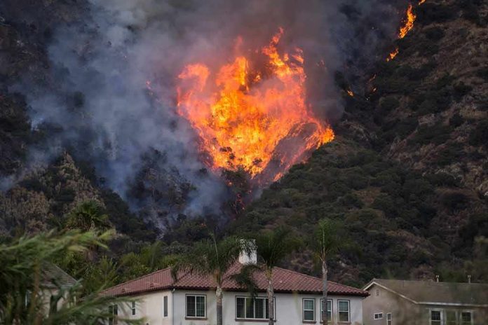
When a wildfire like the Gann Fire races from a few hundred acres to several thousand in a single night, the real story is not the headline adjective “fast-moving,” but the interplay of fuels, terrain, and evacuation decisions that determine whether people get out of the way in time.
Story Overview
- The Gann Fire ignited near Hogan Dam Road and Gann Road in Calaveras County and ran rapidly through dry grass and brush, growing from roughly 300 acres in the evening to thousands of acres by the next day.
- Cal Fire and the Calaveras County Sheriff’s Office issued and then expanded mandatory evacuation orders for multiple Genasys zones east of New Hogan Lake as the fire’s footprint and spotting potential grew.
- For many hours the fire remained 0% contained, with more than 250 firefighters and aircraft attacking steep, rugged terrain under hot, very dry conditions.
- Public information arrived in fragments—incident pages, social alerts, television updates—producing a consistent picture of serious risk, but not yet a granular, zone‑by‑zone rationale for every evacuation decision.
Where and How the Gann Fire Started
The factual backbone of the Gann Fire’s origin is unusually clear for an evolving incident: Cal Fire’s incident listing places ignition at 5:27 p.m. on August 3, 2026, near Hogan Dam Road and Gann Road in the Valley Springs area of Calaveras County. Multiple outlets echo that timing and location, situating the start a mile or so south of New Hogan Lake on the southeastern side of the reservoir. This corridor matters, because it sits in the Sierra Nevada foothills—an environment of continuous grass, brush, and oak woodland where a single ignition can run quickly upslope toward communities scattered along narrow two‑lane roads.
Initial size estimates, as always in a new wildfire, varied with vantage point and mapping precision. CBS Sacramento described about 100 acres burning at a “dangerous rate of spread through grass and brush” before containment was established. Social and local TV updates referenced 30 to 400 acres in the early evening. What is consistent across the record is the fire’s character from the outset: a vegetation fire in light fuels, burning uphill in dry grass and brush at a rate Cal Fire itself labeled dangerous. That assessment, rather than any single acreage number, is what drove the tone of the response.
From Hundreds to Thousands of Acres: Why This Fire Grew So Quickly
By any operational standard, the Gann Fire’s overnight growth was rapid. Evacuation orders went out around 8 p.m. when the fire was just over 300 acres. Cal Fire and outlet summaries then trace a steep climb: roughly 1,800 acres by about 11:30 p.m., 2,100 acres by the early morning hours, and on the order of 3,000 to 3,759 acres once better mapping and daytime overflights were available. Yahoo’s live‑update stream, drawing on Cal Fire data, described the fire “exploding” from 310 acres at 8 p.m. to 1,800 acres by late night, and continuing at 0% containment into Tuesday.
Rapid spread in this case is not a mystery; the ingredients are textbook. First, fuels: reporters on the ground and Cal Fire officials described brush so desiccated it could be broken by hand, with continuous grass carrying flame uphill. Second, weather: daytime highs in the mid‑90s Fahrenheit and light but persistent winds created a deep layer of hot, unstable air over the fire. Third, topography: this section of the Sierra foothills features dissected terrain south of New Hogan Lake, where slopes and canyons can channel wind and accelerate uphill runs.
Once a fire like this is established, embers—or “spotting”—extend the reach beyond the immediate flame front. KCRA’s coverage relayed officials’ warnings that embers from the Gann Fire could travel up to three miles, a plausible range under dry, convective conditions. That spotting potential helps explain why the fire’s perimeter footprint and the area of concern for evacuations grew more quickly than simple head‑fire spread alone would suggest; a spot fire that establishes ahead of the main front can instantly redraw the operational map.
Evacuation Zones: How Authorities Expanded the Footprint
On the human side of the incident, the most consequential decisions were about when to move people. Cal Fire’s early hours were focused on suppression, but within a few hours of ignition, attention shifted decisively to evacuation. The Calaveras County Sheriff’s Office, using its Genasys zone system, issued mandatory evacuation orders for zones CCU‑147, CCU‑109, CCU‑139 and CCU‑110—essentially a swath east of Rancho Calaveras and west of Calaveritas, running from the eastern shore of New Hogan Lake out toward the Calaveras County Airport and Salt Spring Valley Reservoir.
That footprint, roughly 90 square miles by one mapping estimate, reflects a precautionary logic common in foothill fires: draw evacuation boundaries around both the current perimeter and plausible short‑term spread corridors, rather than waiting for flames to reach the first row of homes. Later television updates and social posts refer to additional zoning refinements, including the addition of CCU130B and continued orders for the original four zones. While the supplied record does not include the full text of each written order or a GIS overlay linking perimeter data to zone lines, the convergence of sheriff advisories, Cal Fire incident updates, and media maps is clear on one point: evacuation coverage expanded as the fire’s acreage and spotting risk grew, and remained in place overnight while containment stayed at zero.
Evacuation infrastructure followed quickly. Valley Springs Veterans Memorial Hall—at 189 Pine Street—opened as a shelter for residents and small pets, and the Calaveras County Fairgrounds took in displaced livestock. Road closures on Pool Station Road, Hogan Dam Road, and connecting corridors helped both clear escape routes and give engines and bulldozers room to work. In short, the county moved beyond advisory messaging to a full operational posture aimed at getting people and animals out of harm’s way.
Containment, Suppression Tactics, and the Role of Incident Management
Containment—building and holding lines that fire cannot cross—lagged far behind growth in the first operational period. Across Cal Fire updates and multiple outlets, the Gann Fire is described as 0% contained through the night and into Tuesday morning, even as more than 250 firefighters, engines, hand crews, and aircraft attacked the perimeter. Night‑flying helicopters were deployed, an increasingly standard but resource‑intensive tool reserved for fires where rapid expansion threatens communities.
As acreage climbed toward and past the 3,000‑acre mark, Cal Fire assigned a California Incident Management Team (CIMT) to the Gann Fire, a move confirmed in social reports and agency announcements. CIMTs bring a more formalized command structure: incident action plans, specialized operations (air attack, dozer groups, structure protection), and dedicated public information functions. Their arrival typically signals that a fire has moved beyond initial attack into a sustained campaign, one likely to span multiple days and operational periods.
Terrain limited what those crews could do in the first hours. Reports emphasize “rugged” and “steep” country—conditions that slow hand‑line construction and make direct attack dangerous when flame lengths increase. In such settings, commanders often choose indirect tactics: building line on more favorable ground, using roads and ridgelines, and combining dozer work with burnouts or aerial retardant. Those choices take time; in the interim, containment numbers remain low even if tactical progress is being made.
Information Flow: Why the Public Narrative Looks the Way It Does
The Gann Fire’s public narrative illustrates a recurring pattern in wildfire coverage. Early information is fragmented across Cal Fire incident pages, county sheriff social feeds, TV live shots, and outlet summaries, each with slightly different time stamps and acreage snapshots. As a result, the story the public sees is built from stitched‑together operational fragments rather than from a single comprehensive, retrospective memo.
Several consequences follow. First, emphasis: because the most urgent facts are growth, containment, and evacuations, headlines naturally compress the complexity into “fast‑moving fire,” “grows to more than 3,700 acres,” and “evacuation orders expand.” That framing is not inaccurate—the fire did in fact grow rapidly and trigger mandatory evacuations—but it leaves little room for the underlying logic of exactly why each zone line falls where it does, or which specific neighborhoods faced imminent flame contact versus precautionary risk.
Second, documentation lag. Command decisions, particularly evacuation calls, are typically documented in written orders, ICS‑209 situation reports, and perimeter maps, but those instruments are not always immediately accessible to the public or the press. In the Gann Fire record, we see clear evidence that orders were issued and shelters opened, but not yet the detailed threat assessments or GIS overlays that linked spreading fire to each boundary decision. That gap is structural, not sinister: operational tempo outruns paperwork, and only later will a full archive emerge.
Third, geographic ripple effects. Smoke from the Gann Fire drifted well beyond its footprint—north and east into El Dorado, Placer, Sierra Nevada, Sacramento, and potentially Tuolumne counties—bringing the sensory reality of the fire (visible plumes, smell of smoke) to populations far outside the evacuation zones. That broader attention can amplify pressure for information while simultaneously simplifying the narrative for distant audiences: they see “big fire, bad air,” not the nuanced calculus of local zone management.
What We Know Solidly—and What Remains Undocumented
On the core facts, the evidence record around the Gann Fire is coherent and uncontested. There is no primary‑source rebuttal disputing Cal Fire’s characterization of the fire as dangerous and fast‑moving through grass and brush, nor any alternative timeline or location for ignition. Every credible source aligns on the basics: ignition near Hogan Dam and Gann roads around 5:27–5:30 p.m.; rapid growth to thousands of acres within hours; 0% containment through the first night; mandatory evacuations across named Genasys zones east of New Hogan Lake; and activation of human and animal shelters.
Where the record is thinner is in zone‑level justification: we do not yet see the written evacuation orders themselves, perimeter‑to‑zone GIS overlays, individual structure‑threat assessments, or sworn command testimony explaining the thresholds for adding each zone. For an analyst reconstructing the incident months later, those materials would be essential to evaluate proportionality—whether the footprint of evacuation matched the best available science on spread potential, spotting, and ember travel. For residents making decisions in real time, however, the operational facts that did reach them—rapid spread, no containment, extremely dry fuels, and the sheriff’s directive to go—were more than enough to justify leaving.
Understanding that distinction is key to reading wildfire coverage intelligently. In the first 24 hours of a fast‑moving fire, the goal of incident communication is public safety, not the production of a forensic case file; the latter arrives later via records requests, after‑action reviews, and fire‑behavior analyses. The Gann Fire fits that pattern cleanly. It is a case study in why foothill communities rely on zone‑based evacuation systems, why Cal Fire invests in night‑flying aviation and incident management teams, and why “fast‑moving” in a headline, while imprecise in scientific terms, is often a fair reflection of the lived risk that drives people from their homes.
The Gann Fire has burned at least three different homes on Jaquima Drive in Calaveras County. See more updates: https://t.co/oeMg3uCpIQ pic.twitter.com/84lT4arlZg
— kcranews (@kcranews) August 4, 2026
Why This Fire Matters Beyond Calaveras County
For readers far from the Sierra foothills, the Gann Fire is not just another number in a seasonal tally. It illustrates how modern wildfire response integrates real‑time science—fuel conditions, topography, weather—with increasingly sophisticated public‑alert infrastructure, and how that integration is strained when a fire outruns the pace of documentation. It also underscores a simple truth: in landscapes primed by heat and drought, a single ignition along a road corridor can become a county‑scale event in a matter of hours.
As more communities adopt zoned evacuation maps and as incident teams refine their use of satellite perimeters, modeling, and alert platforms, the gap between operational decision and public explanation should narrow. Until then, episodes like the Gann Fire will continue to look, from the outside, like sudden expansions under a generic banner of “fast‑moving flames.” To understand them properly, one has to look behind the headline—to the origin point near Hogan Dam Road and Gann Road, the grass and brush that carried the fire uphill, the embers that leapt ahead, and the people who packed a bag and drove to Valley Springs Veterans Memorial Hall when the sheriff said “go.”
Sources:
nypost.com, sfchronicle.com, sfgate.com, youtube.com, kcra.com, fire.ca.gov, kioncentralcoast.com, mercurynews.com, fresnobee.com, mymotherlode.com, cbsnews.com, facebook.com